With ever-shrinking pristine habitats across the region and globe, wildlife is often hard-pressed to find a place to call home. Even if they find a suitable home today, the question remains if it will still be suitable tomorrow. With climate change already underway and increasing human presence in wild landscapes, land managers and conservation organizations continually wrestle with this issue here in the Pacific Northwest and across the world.
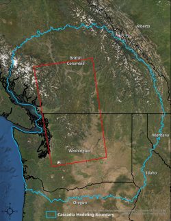
These complexities make conservation planning difficult, but the Cascadia Partner Forum is an organization primed to tackle it. Its focus is on Cascadia, an area rich in both plant and animal diversity that encompasses much of Washington and southern British Columbia. The Forum is an outlet where many entities, big and small, can pool their best thinking to coordinate approaches to conservation.

“Conservation of biodiversity is our focus, looking very much through a climate impacts lens and assessing the future risks from climate change as well as our expanding human footprint,” says Andrew Shirk, research scientist at the UW Climate Impacts Group and a member of the Forum. “There are lots of assessments out there, but there is no organization that is working across boundaries for conservation at the scale of Cascadia. The Forum leads coordination and climate adaptation strategy for the region.”
Shirk is leading an effort to build a game-changing conservation tool that helps stakeholders like regional land managers, private landowners, timber companies, conservation organizations and federal, state, and provincial officials better understand where they might focus their habitat restoration and protection efforts. It helps users identify where there is suitable habitat and if it might remain so into the future; where new areas of habitat might arise in the future; where habitat may be at highest risk; where restoration efforts might have the most benefit; and the connections between habitats. Climate change projections are part of each consideration.
“The Regional Spatial tool we’re developing with land managers provides a wealth of models and data layers that can guide land-use decisions around maintaining biodiversity and protection of some priority species — like lynx, wolverine, sage grouse, grizzly bear, salmon and others,” says Shirk. “The tool allows you to look at, say, where the best habitat is for lynx, if it’s connected, how the range might shift and what the risks are — like fire, timber harvest or urban expansion. The models show risks and opportunities over time for species.”
Key components to conservation are protecting good habitat and maintaining landscape connectivity and the planning tool addresses both. “We’re expecting potentially large range shifts for some species, and they will need a permeable landscape in which to move,” Shirk says. Barriers like highways, urban expansion and landscape changes brought on by climate change can keep animals isolated and render conservation planning and efforts moot.
Another remarkable aspect of the tool is its near real-time abilities, thanks to new cloud computing and storage technologies. Largely using information from satellites, data can be updated frequently. This is a departure from the past, where collecting comprehensive environmental data was painstakingly difficult and required tremendous amounts of time and money. Those data, rarely updated, would often dictate the trajectory of conservation actions for years into the future. Now, recent changes in the landscape can be detected quickly and give conservation leaders the chance to change their tactics and maximize conservation success.
This leap forward in capability is underpinned by tech giant Google and its Earth Outreach team. Once Google learned of the Forum and its goals, it offered assistance in the form of expertise, technology and even allocated staff to help create this powerful planning tool.
“The use of this technology has been a revelation,” says Shirk. “Going to Google Earth has been so powerful. This is something we’ve never had—conservation that can react in near real-time to changes on the ground. Going outside of Cascadia, there has been a big interest in this being applied in other places.”
The tool helps support and bring to life the Forum’s overall strategy, which rests on five pillars: the authority to act; cooperation among all stakeholders; technological capacity to make smart decisions; motivation towards common goals; and funding to support implementation.
“When we think about land-use planning around climate change, it’s usually done in a qualitative way, without a detailed spatial understanding of risks and opportunities,” Shirk says. “Without regional-scale coordination and a spatial understanding of the problem, we’re on a path where many species could become imperiled. We need to protect a broad network of connected habitats that is resilient to climate change. It’s the way we can retain the most of Cascadia’s rich biodiversity and all the benefits that provides to our region.”