138 news posts related to Geophysical Sciences

Return to News

Bubble streams off Washington’s coast provide clues to what will happen during a major earthquake

Bubble Plumes off Washington Coast

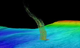
Off the coast of Washington, columns of methane bubbles are being squeezed out of sediment and rising up through the water. A study by the University of Washington and Oregon State University suggests that the locations of these bubble plumes provide important clues to what will happen during a major offshore earthquake. Analysis of the underlying geology suggests that the bubbles emerge here because of the gas and fluid rising through faults which are generated by the motion of geologic plates—the same plates that produce major offshore earthquakes in the Pacific Northwest. 

Read more at UW Today »

One year into the mission, autonomous ocean robots set a record in survey of Antarctic ice shelf

A Seaglider, with the Getz Ice Shelf in the background, being prepared for deployment in January 2018 under the neighboring Dotson Ice Shelf.

A team of ocean robots deployed in January 2018 have, over the past year, been the first self-guided ocean robots to successfully travel under an ice sheet and return to report long-term observations. Beyond mere survival, the robotic mission — a partnership between the University of Washington’s College of the Environment, the UW Applied Physics Laboratory, the Lamont-Doherty Earth Observatory of Columbia University, the Korean Polar Research Institute and Paul G. 

Read more at UW News »

UW glaciologist gets first look at NASA’s new measurements of ice sheet elevation

Since ICESat-2 launched in September, it has already exceeded expectations. It's measuring the height of sea ice to within an inch, which will be used to improve climate modeling and forecasts.

Less than three months into its mission, NASA’s Ice, Cloud and land Elevation Satellite-2, or ICESat-2, is already exceeding scientists’ expectations. The satellite is measuring the height of sea ice to within an inch, tracing the terrain of previously unmapped Antarctic valleys and measuring other interesting features in our planet’s elevation. Benjamin Smith, a glaciologist with the University of Washington and member of the ICESat-2 science team, shared the first look at the satellite’s performance at the American Geophysical Union’s annual meeting Dec. 

Read more at UW Today »

Q&A with Harold Tobin, director of the Pacific Northwest Seismic Network

Harold Tobin aboard the research vessel Marcus G. Langseth, conducting a marine seismic reflection survey of the Cascadia Subduction Zone off Washington’s coast.

Earthquake expert Harold Tobin joined the UW this fall as professor of Earth and space sciences and director of the Pacific Northwest Seismic Network. While he comes from a faculty position at the University of Wisconsin, he’s no stranger to the risks posed by offshore faults like the Cascadia Subduction Zone, the source of our “big one.” UW News sat down with Tobin to learn a bit more about his research, experience and plans for the UW-based Pacific Northwest Seismic Network, a coalition among the U.S. 

Read more at UW Today »