73 news posts related to Extreme Environments

Return to News

New radar technology sheds light on never-before-seen Antarctic landscape

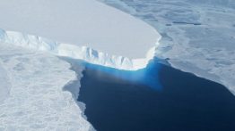
17,000 years ago, Seattle was covered by an ice sheet that stood over 3,000 feet tall (for reference, the current tallest building in Seattle, the Columbia Tower, is just under 937 feet). As the ice advanced and eventually receded, it carved massive valleys, mountains and lakes into the earth to create the glaciated land and seascape we recognize today. These landscapes not only remind us of the area’s ancient glacial past but also provide tools to understand and predict future patterns for glaciers. 

Read more »

Super salty, subzero Arctic water provides peek at possible life on other planets

In recent years, the idea of life on other planets has become less far-fetched. NASA announced June 27 that it will send a vehicle to Saturn’s icy moon Titan, a celestial body known to harbor surface lakes of methane and an ice-covered ocean of water, boosting its chance for supporting life. On Earth, scientists are studying the most extreme environments to learn how life might exist under completely different settings, like on other planets. 

Read more at UW News »

One year into the mission, autonomous ocean robots set a record in survey of Antarctic ice shelf

A Seaglider, with the Getz Ice Shelf in the background, being prepared for deployment in January 2018 under the neighboring Dotson Ice Shelf.

A team of ocean robots deployed in January 2018 have, over the past year, been the first self-guided ocean robots to successfully travel under an ice sheet and return to report long-term observations. Beyond mere survival, the robotic mission — a partnership between the University of Washington’s College of the Environment, the UW Applied Physics Laboratory, the Lamont-Doherty Earth Observatory of Columbia University, the Korean Polar Research Institute and Paul G. 

Read more at UW News »

UW glaciologist gets first look at NASA’s new measurements of ice sheet elevation

Since ICESat-2 launched in September, it has already exceeded expectations. It's measuring the height of sea ice to within an inch, which will be used to improve climate modeling and forecasts.

Less than three months into its mission, NASA’s Ice, Cloud and land Elevation Satellite-2, or ICESat-2, is already exceeding scientists’ expectations. The satellite is measuring the height of sea ice to within an inch, tracing the terrain of previously unmapped Antarctic valleys and measuring other interesting features in our planet’s elevation. Benjamin Smith, a glaciologist with the University of Washington and member of the ICESat-2 science team, shared the first look at the satellite’s performance at the American Geophysical Union’s annual meeting Dec. 

Read more at UW Today »

Polar bears gorged on whale carcasses to survive past warm periods, but strategy won't suffice as climate warms

Four male polar bears standing on a floating whale carcass shortly after it drifted to shore on the island of Svalbard.

Polar bears likely survived past warm periods in the Arctic, when sea ice cover was low, by scavenging on the carcasses of stranded large whales. This food source sustained the bears when they were largely restricted to land, unable to roam the ice in search of seals to hunt. A new study led by the University of Washington found that although dead whales are still valuable sources of fat and protein for some polar bears, this resource will likely not be enough to sustain most bear populations in the future when the Arctic becomes ice-free in summers, which is likely to occur by 2040 due to climate change. 

Read more at UW Today »