Q&A: ShakeAlert earthquake early warning system arriving in Pacific Northwest
After years in development, an earthquake early warning system known as ShakeAlert is on the cusp of being released in Oregon and Washington. The system that spans the West Coast was launched in California in late 2019. It launches to the public in Oregon on March 11, the 10th anniversary of the Tohoku earthquake and tsunami, and in Washington in May.
The system was developed through a partnership between the University of Washington and other West Coast universities and the U.S. Geological Survey working with state emergency management districts. The system uses ground sensors across the region to detect the first signals from a rupturing earthquake and then sends that information to computers and phones, providing seconds to tens of seconds of warning of an imminent earthquake.
Marine organisms use previously undiscovered receptors to detect, respond to light
Dror Shitrit/Simons Collaboration on Ocean Processes and Ecology
Field samples were collected during a 2015 cruise in the North Pacific. Co-author Bryndan Durham (center) recovers the sampling instrument. The gray bottles open and close at specific depths to collect seawater samples.
Just as plants and animals on land are keenly attuned to the hours of sunlight in the day, life in the oceans follows the rhythms of the day, the seasons and even the moon. A University of Washington study finds the biological light switches that make this possible.
Single-celled organisms in the open ocean use a diverse array of genetic tools to detect light, even in tiny amounts, and respond, according to a study published the week of Feb. 1 in the Proceedings of the National Academy of Sciences.
“If you look in the ocean environment, all these different organisms have this day-night cycle. They are very in tune with each other, even as they get moved around. How do they know when it’s day? How do they know when it’s night?” said lead author Sacha Coesel, a research scientist in oceanography at the UW.
Though invisible to the human eye, ocean microbes support all marine life, from sardines to whales. Knowing these communities’ inner workings could reveal how they will fare under changing ocean conditions.
“This work dramatically expanded the number of photoreceptors — the different kinds of those on-off switches — that we know of,” said senior author Virginia Armbrust, a UW professor of oceanography.
Global warming found to be culprit for flood risk in Peruvian Andes, other glacial lakes
As the planet warms, glaciers are retreating and causing changes in the world’s mountain water systems. For the first time, scientists at the University of Oxford and the University of Washington have directly linked human-induced climate change to the risk of flooding from a glacial lake known as one of the world’s greatest flood risks.
The study examined the case of Lake Palcacocha in the Peruvian Andes, which could cause flooding with devastating consequences for 120,000 residents in the city of Huaraz. The paper, published Feb. 4 in Nature Geoscience, provides new evidence for an ongoing legal case that hinges on the link between greenhouse gas emissions and particular climate change impacts.
“The scientific challenge was to provide the clearest and cleanest assessment of the physical linkages between climate change and the changing flood hazard,” said co-author Gerard Roe, a UW professor of Earth and Space Sciences.
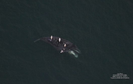
A bowhead whale carcass. (NMFS Permit No. 14245-3. Funded by BOEM [M11PG00033])From a small aircraft flying over the Pacific Arctic, scientists with the Aerial Surveys of Arctic Marine Mammals (ASAMM) project surveyed the movements and interactions of marine mammals for more than four decades. Observations and images from these surveys offer clues informing our understanding of the lives, and deaths, of marine mammals in this remote region.
A new study, published in Polar Biology and led by researchers at the University of Washington’s Cooperative Institute for Climate, Ocean, and Ecosystem Studies (CICOES), is particularly interested in the ‘death’ part of those survey observations, and has uncovered the first direct evidence of killer whales as the primary cause of death for one of the Arctic’s endangered species, bowhead whales of the Bering-Chukchi-Beaufort seas stock.
By analyzing aerial images of bowhead whale carcasses from 2009 to 2018 and cross-referencing sightings with the timing of reported whale strikes by Alaska Native hunters, researchers attributed cause of death to either probable killer whale predation or aboriginal subsistence hunting. In some instances, cause of death could not be determined when injuries were absent or not significant enough to suggest killer whale predation, the carcass was too decomposed or image quality was too poor.
Killer whales are bowhead whales’ only natural predator, and while encounters between the two species have never been witnessed in the eastern Chukchi and western Beaufort seas, killer whale predation on bowhead whales have been seen throughout many other regions where their ranges overlap. Lead author Amy Willoughby, a research scientist with CICOES and NOAA’s Alaska Fisheries Science Center (NOAA AFSC), emphasizes the potential metabolic effects for bowhead whales when killer whales are present. “When killer whales are nearby, bowhead whales may try to move farther away which uses energy, and killer whale presence can disrupt feeding opportunities.”
Kate Pagan
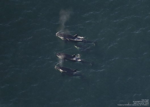
A pod of killer whales. (NMFS Permit No. 20465. Funded by BOEM [IA Contract No. M17PG00031])The study’s authors point to climate change as the likely culprit behind the emergence of these attacks in the Arctic, as killer whales can now access bowhead whales in this segment of their range. “Increased temperatures in the Arctic have reduced sea ice, and decreased sea ice has allowed killer whales to access areas that were less accessible when sea ice created choke points that they could not pass. Bowhead whales who use sea ice to avoid predators have limited sea ice available to retreat to, so now we have killer whales predating on bowhead whales in new locations,” Willoughby explains.
Bowhead whales are valuable sociocultural resources for the Alaska Native communities who rely on them for subsistence. Inuit and Yupik studies provide much of the existing evidence for successful killer whale predation on bowheads outside of the eastern Chukchi and western Beaufort seas. “The Arctic is a very unique place to conduct research because you have the opportunity to collaborate with Alaska Native community members who have a direct connection to the marine environment, hold hundreds of years of traditional ecological knowledge and are often the first to observe changes,” said Willoughby.
A number of questions remain surrounding the effects of killer whale predation on bowhead whale populations and behavior. To avoid encountering killer whales, Bering-Chukchi-Beaufort bowhead whales could migrate further north beyond the range of killer whales or move into shallower water along the coastline, a strategy the species has adopted in other areas. Other whale species, such as gray whales in the eastern Pacific, also migrate near the coastline to avoid killer whales.
Corey Accardo
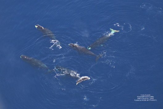
A group of bowhead whales. (NMFS Permit No. 20465. Funded by BOEM [M17PG00031])Ultimately, these findings are not a game changer but “an important clue to help play the game better,” as Willoughby describes it. “The Arctic is rapidly warming and as a result, commercial fishing and shipping is expected to increase. The findings from our study will help provide context for interpreting future information on bowhead whale mortality occurrence and causes of death.”
Willoughby and her collaborators are continuing their work examining whale mortality for different species in the Arctic. “I’m hoping to publish our findings for gray whale carcasses in the eastern Chukchi Sea, bowhead whale carcass data from 2019 which was a bit different compared to 2009-2018, and I’d really like to analyze our bowhead whale imagery to summarize entanglement scarring encounter rates for free swimming bowhead whales sighted during our aerial surveys,” she says.
These exciting new results are somewhat bittersweet. After 41 years, ASAMM no longer has funding and its annual surveys have concluded. “At a time when the Arctic is changing at an unprecedented rate, there is currently no plan for continued annual large scale aerial monitoring of marine mammals in the Arctic, and I can’t help but worry about what we’re missing,” Willoughby surmises. “I’d like to thank my co-authors, the Bureau of Ocean Energy Management who funded this important project for so many years, the NOAA AFSC Marine Mammal Laboratory who co-managed the project, and all of the flight crews, biologists and collaborators.”
For further reading on this topic and whales in the Arctic, check out:
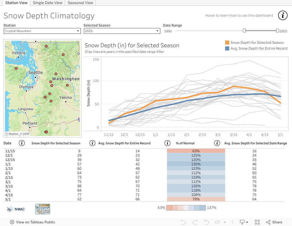
How’s the snow on Northwest mountains this year? Overall a little deeper than normal, but it depends where you look. A new collaboration between the University of Washington and the Northwest Avalanche Center lets you see how the current snow depth compares to past years for nine sites in Washington and two in Oregon.
The new mountain snow depth tool is freely available on the Office of the Washington State Climatologist’s website. It replaces a tool made more than a decade ago that collected snow depth data from the NWAC website to create a simple graphic on the state climatologist’s website.
“When that display wasn’t working, that’s the one where we would get emails from ski enthusiasts or other meteorologists or climatologists. To us that was a good sign that we should rebuild it,” said Karin Bumbaco, a Cooperative Institute for Climate, Ocean, and Ecosystem Studies research scientist who is the assistant state climatologist.
The new version, built with support from Tableau, is interactive, displays more data and is more reliable. It lets users explore differences in mountain snow depth from one season to the next and create a graphic of the results.
“This is a tool that people in the weather community, like meteorologists and climatologists, as well as snow recreationalists, can use to communicate the current snow conditions and how they relate to average conditions and previous years,” Bumbaco said.
A default view shows the current year compared to the past 30 years of data at a single location. Changing the settings can display measurements back as far as 1927 for the longest-running stations, on Mount Baker and at Paradise on Mount Rainier. Measurements go back to 1974 for the two most recent stations, at Mount Hood Meadows and Timberline in Oregon.
Nick Tritt walking in his 15-Minute Neighborhood during the pandemic.
As cities become more densely populated, urban planning has traditionally focused more on improving transit infrastructure to move as many vehicles as possible, helping citizens get from home to work, the grocery store, local coffee shop, health center or nearest park. With so much time spent driving in vehicles, cities are facing growing air and noise pollution, while humans are facing social isolation and numerous health impacts from sitting in a car.
Enter the concept of a 15-minute neighborhood, which brings amenities to people rather than relying on transit to bring people to amenities. This approach aims to improve quality of life by creating neighborhoods where everything a resident needs can be accessed within 15 minutes, whether it be green space, retail and grocery stores, medical offices or everything in between.
Program on the Environment student Nick Tritt presented on this concept for his Capstone project, supplementing research with an internship with pedestrian and cyclist advocacy group Seattle Neighborhood Greenways. As a resident of downtown Seattle, Tritt lives in an area with a walk score of 99 – just about as walkable as an area could be. “I walk everywhere and I pretty much live a car-free life. Without realizing it, I have always sought out neighborhoods that are walkable so this internship was number one on my list,” says Tritt.
Starting research when the pandemic began, Tritt combed through peer-reviewed sources including academic papers, and pedestrian and walking journals. All the resources broke down the concept of a 15-minute neighborhood into two research categories: transportation sites (U.S., local and regional) and city plans.
This effort to make neighborhoods more pedestrian-focused was named and popularized as the “15-minute city” by Paris Mayor Anne Hidalgo. Although the term is fairly new, cities have been rethinking the way neighborhoods are structured to accommodate for walking and biking rather than for cars and other motorized vehicles. Some cities are already acting on this concept. Barcelona has “super blocks”, which modified the existing city plan with limited room for cars and parking. The city used the existing infrastructure and turned the super blocks into a grid system, each with its own neighborhood complete with courtyards, green spaces and gathering spaces. Singapore and Melbourne also adopted the concept and have a 20-minute neighborhood with city planning centered around pedestrians. More locally, we look to Portland, Oregon as an example of a 20-minute neighborhood that has proven to be successful.
“When looking into what people need, we need to look at their shopping habits and consumer habits,” said Tritt. “That drives a lot of traffic – especially grocery shopping. Grocery stores are a great indicator of walkability because grocery shopping is a big part of what people do.”
What about areas that might not be as densely populated, like suburbs or rural areas?
One idea is cul-de-sac suburbs, where transit hubs bring people from one hub to another hub where there are services. People will drive to something like a park and ride, and take public transportation into a walkable area or another hub. Another option is to utilize existing spaces for pop-up shops or food trucks, bringing markets to suburban areas in parking lots or mobile businesses to introduce walkability to suburbs. These ideas then spur new thinking about different ways to utilize other spaces: can we use school parking lots on the weekends, where they sit empty for two days of the week? What about church parking lots? “Remixing” pre existing spaces may be a way to bring markets to neighborhoods and increase walkability.
Stay Healthy Streets is an initiative that was introduced as a result of COVID-19, where closed off residential streets allow for a safe way to get outside and walk to essential services, support small businesses and get some exercise while maintaining social distancing. These streets still allow for people living in the area, waste pickup and deliveries to still continue driving on the roads.
According to the City of Seattle, the response to the Stay Healthy Streets program has been generally positive: “Observations indicate people of all ages are using the Stay Healthy Streets and travelers are following #KeepItMoving guidelines. About 10 to 40 people per mile are walking and biking in the streets depending on the location. The Keep Moving Streets near destination waterfront parks have seen the most use compared to locations along neighborhood greenways. People walking have room to spread out on both sidewalks and the street, while most people running or biking are using the street. We’ve also seen an increase in parents using the streets with their kids on bikes, scooters and big wheels along with lots of chalk drawings.”
Continuing to build upon the habits people have started forming due to the pandemic like walking more, driving less, staying more local for their needs, and supporting local businesses has been a great primer to encourage people to rely less on transportation and instead walk or bike to run errands. Plus, with stay-at-home orders limiting the amount of traveling people are doing, many are turning to local parks and outdoor areas to get that dose of nature.
“I feel like a lot of people look for walkable areas on vacation because they don’t have their usual means of transportation. If people can experience walkability at home, I think that most people would enjoy it. Walking around is a part of sightseeing as well – it makes walkability interesting in addition to functional because it brings some character and nature in,” says Tritt.
One faculty member at UW Environment was awarded an early-career fellowship from the Alfred P. Sloan Foundation. The new Sloan Fellow, announced Feb. 16, is Jodi Young, an assistant professor in the School of Oceanography.
Open to scholars in eight scientific and technical fields — chemistry, computer science, economics, mathematics, molecular biology, neuroscience, ocean sciences, and physics — the fellowships honor those early-career researchers whose achievements mark them among the next generation of scientific leaders.
The 128 Sloan Fellows for 2021 were selected in coordination with the research community. Candidates are nominated by their peers, and fellows are selected by independent panels of senior scholars based on each candidate’s research accomplishments, creativity, and potential to become a leader in their field. Each fellow will receive $75,000 to apply toward research endeavors.
Young is an assistant professor in the School of Oceanography. She studies microbial oceanography, with a focus on the role of marine algae in the carbon cycle. In particular, her research explores polar ecosystems and other extreme environments, and the biochemistry of photosynthesis. Her research combines field work, algal culture manipulations, and biochemical and molecular analyses to uncover the evolution and adaptations of biological carbon fixation in the oceans.
“Half of all photosynthesis happens in the oceans, across an amazingly diverse collection of organisms,” Young said. “My group’s research focuses on understanding the underlying physiological and molecular adaptations of marine photosynthesis. Understanding how marine algae have and will adapt to a changing climate reveals insights into how life on Earth evolved and will respond in the future.”