17,000 years ago, Seattle was covered by an ice sheet that stood over 3,000 feet tall (for reference, the current tallest building in Seattle, the Columbia Tower, is just under 937 feet). As the ice advanced and eventually receded, it carved massive valleys, mountains and lakes into the earth to create the glaciated land and seascape we recognize today. These landscapes not only remind us of the area’s ancient glacial past but also provide tools to understand and predict future patterns for glaciers.
A new study published in the journal Geology by University of Washington Earth and Space Sciences researcher Nick Holschuh may hold the key to making those predictions more precise. Holschuh and his collaborators deployed radar technology called swath radar for the first time to peer through a present-day ice sheet in Antarctica and accurately map its hidden landscape below.

“This technology really is a game-changer in a lot of ways,” explains Holschuh. “The detail that it provides is phenomenal, and lets researchers ask new questions and answer many older ones.”
Using swath radar processing techniques, researchers hope to compare landforms from post-glacial environments (like that of Seattle) to those formed by an active glacier. Similar to how the now-famous LiDAR technology peeled back the impenetrable jungles of Mesoamerica and transformed our understanding of Mayan civilization, swath radar allows researchers to see through thousands of feet of ice and snow to reveal familiar valleys and hills below.
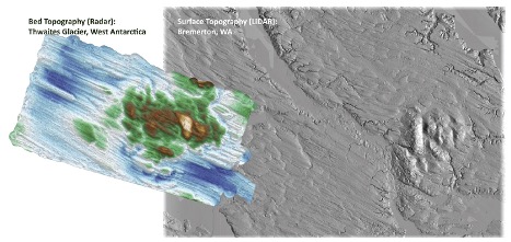
“One of the most striking images compares a landscape we mapped at the base of Thwaites Glacier and the landscape just outside of Bremerton, mapped with airborne LiDAR”, says Holschuh. “It is incredible to see features like those in our own backyard forming right now under the Antarctic ice sheets.”.
“It is incredible to see features like those in our own backyard forming right now under the Antarctic ice sheets.”
Nick Holschuh
In 2020, three ice sheets remain worldwide — two constituting Antarctica, and one in Greenland. In the era of anthropogenic climate change, the majority of our northern hemisphere ice is disappearing, and it has become essential that we understand how these massive ice sheets will respond to increasing global temperatures. A critical component is learning how historical ice sheets behaved as they receded thousands of years ago, and swath radar could further scientists’ understanding.
Using glacial “fingerprints” of landscapes previously covered by ice sheets, glaciologists create mathematical models that help explain how glaciers behave as they move across Earth’s surface. These inform predictions of glacier retreat and, ultimately, sea-level rise due to melting activity. However, validating these models is challenging.
With the new map of Thwaites Glacier’s bedform, the team was able to take the revealed landscape and use it to test their models. What they discovered was that some observations fit their model’s predictions and others did not. For example, glacial remnants that often create an elongated, narrow hill – a typical formation geologists call a mega-scale glacial lineation — is thought to form by rapidly flowing ice or water at the base of a glacier. Yet data based on swath radar did not mesh with this explanation, suggesting the exact mechanism by which they were shaped remains unknown.
The study’s findings are valuable in their own right, yet its impact proving the concept of swath radar is even more significant. As more glaciers are mapped using advanced radar techniques, there will be more data available for researchers to hone their glacier models and more accurately describe the activity of glaciers such as Thwaites Glacier in the context of a changing climate. “The possibilities of swath radar processing technologies are nearly limitless, and I’m very excited to see how it’s used and what insights we will glean from it,” says Holschuh.
Researchers stress that this is a single study on a single glacier, and future studies are needed to reproduce these findings. Thanks to swath radar, those studies should be forthcoming.