The Puget Sound area is vulnerable to several types of seismic risks. We might fixate on “The Really Big One” – the offshore hazard famously profiled in The New Yorker – but other dangers lurk closer underfoot, and might actually deliver more damage to Seattle.
The nature of the ground beneath the city — a roughly 4-mile-deep basin filled with soil and soft rock — makes the urban core especially vulnerable to seismic shaking.
“In our 3D simulations, we see these basins light up with strong shaking, but we need to verify that these basins are shaped the way we think they are,” said Alex Hutko, a research scientist with the Pacific Northwest Seismic Network based at the University of Washington. “We know the basics, but there’s a lot of useful detail that could help us strengthen infrastructure in the right locations.”
Hutko is coordinating volunteers for a series of experiments, and is lead scientist of one of them, all of which aim to better map the Seattle Basin and study how the soft fill can magnify and distort the trapped seismic waves that can slosh back and forth like water in a bathtub.
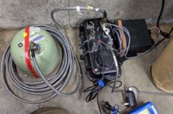
The UW group has six very sensitive seismometers that can detect both fast and slow shaking. The researchers will put them out for three to six weeks at each site, moving from the Seattle area gradually south toward Tacoma.
“It seems crazy to put very sensitive instruments in the middle of a noisy city,” said Paul Bodin, a UW research professor of Earth and space sciences. “Seattle has all kinds of ambient vibrations — traffic, waves on bodies of water, wind blowing on buildings, trains. It’s a situation that most seismologists would run from. But in this case, that noise is providing us with the data.”
The first round of data collection, now under way, includes a site at Woodland Park Zoo and other cement floors north of Seattle’s ship canal. Hutko’s team will remove the equipment in the first week of June and install the six instruments at new sites, moving slightly southward each time. They hope to eventually expand the study’s scope to include neighboring sedimentary basins in Tacoma, Everett and beyond.
Puget Sound residents who want their property to be considered to host a station can submit their address and contact information at https://pnsn.org/about/seattle-tacoma-urban-experiment.
Read more at UW News »