Feeling cool, wet sand squish between your toes while walking along a beach is something that many of us take solace in — there’s just something special about that boundary between land and water. The beach serves as the backdrop for so many of life’s events: vacations, barbeques, camps, seashell searches, sporting events and even weddings. But the sand you track in on your towels and sandals is more than just something to vacuum up. Studied closely, it can reveal the ancient history of our planet, help us predict earthquakes and even provide keys to climate change resilience.
From glaciers and rivers to assorted beaches
Andrea Ogston, a professor in the College of the Environment’s School of Oceanography, studies the processes that help shed light on the many stories of sand. “We use information about sand’s composition — what minerals it’s made up of, what we know about the coastal circulation and waves and concepts of how sediment moves in response to the waves and currents,” she explained. “We can use these things together to find what the source was and how it got there.”
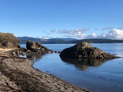
For instance, most of the sand in the Salish Sea and the Strait of Juan de Fuca comes from glacial processes that were active around Seattle approximately 17 thousand years ago. As the ice moved across the land, scraping and grinding up rocks and minerals as it went, it brought various types of sediment to the beaches. “On our beaches there’s a lot of big, coarse cobble material and a lot of sandy material, which is really indicative of glacial sediments,” Ogston said. “The grain sizes are mixed up, and there haven’t been a lot of strong physical processes to sort out specific sizes, so you have a bit of everything on our beaches in the Puget Sound.”
Yet, the sediment on beaches along southwest Washington’s open coast is different — the grains are smaller in size, like typical “beach-walking” sand. This sand comes from a mix of sources, primarily rivers and landslides. Once the sediment moves from the mouth of a river to the coastline, the waves along the coast sort the sand to make the beaches we walk on. “Even if there was quite a variety of grain sizes or different sources of sediment, the wave action acts as a big blender and makes the sand sizes pretty consistent,” said Ogston.
In addition to glaciers and rivers, sand also comes from coral reefs, volcanoes and minerals that fall out — or precipitate — from the water column. Many island beaches near coral reefs are made up of fine, white sand that comes directly from the corals themselves. Black sand beaches form in areas with volcanic activity, where the ocean breaks down lava and other volcanic materials. There are even areas in the world with red, pink, green and purple sandy beaches; their color depends on the types of minerals found in that area.
How sand helps us predict the future
Sand can also tell researchers a story about the history of the Earth using stratigraphy, which is the study and classification of different layers of sedimentary deposits. The stratigraphic record can tell us about earthquakes, floods and wave events from hundreds to thousands of years ago. For instance, a massive flood in a river could cause a large supply of sediment to be deposited along the shoreline, drastically changing a beach’s composition. “Understanding how these sediments get here, what their source is, what their composition is and the pathways they take to get to any specific site allows us to read this geologic history of our shorelines,” Ogston explained.
The stratigraphic record can also tell us about past earthquakes. “One of the ways people have obtained the frequency of large earthquakes associated with the Cascadia subduction zone is by looking for specific types of deposits that tend to be sand rich,” said Ogston. Today, scientists find mostly fine sediment depositing in the deep waters of submarine canyons that incise the continental slope of the Cascadia margin. But within the seabed deposits they may see coarse layers, which suggests there was a very energetic event, like an earthquake, that caused these sands to move from the continental shelf into deeper environments. Using this knowledge, along with other tools and models, researchers can understand the frequency that earthquakes have occurred in the past and can make predictions about earthquake frequency in the future.
Understanding the patterns of sand also has significant implications for coastal communities, especially at a time of climate change and rising sea levels. The National Science Foundation’s Cascadia Coastlines and Peoples project is an interdisciplinary initiative aimed at understanding coastal hazards, such as erosion and flooding, to increase coastal communities’ resilience. Scientists and community members work together to predict how our coastlines might change to mitigate potential issues and to plan for the future.
To see the processes of sand for yourself, the next time you walk out along the Washington coast, pay attention to how the beaches change as you move from the Columbia River to the Strait — or even from one cove to the next. After all, sand is science at your fingertips.
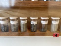
Check out Richard Sternberg’s Sand Collection in the lobby of the Ocean Sciences Building to see examples of the incredible diversity of different types of sand.