Timing is everything: ShakeAlert comes to Washington May 4
It could happen any time, any day.
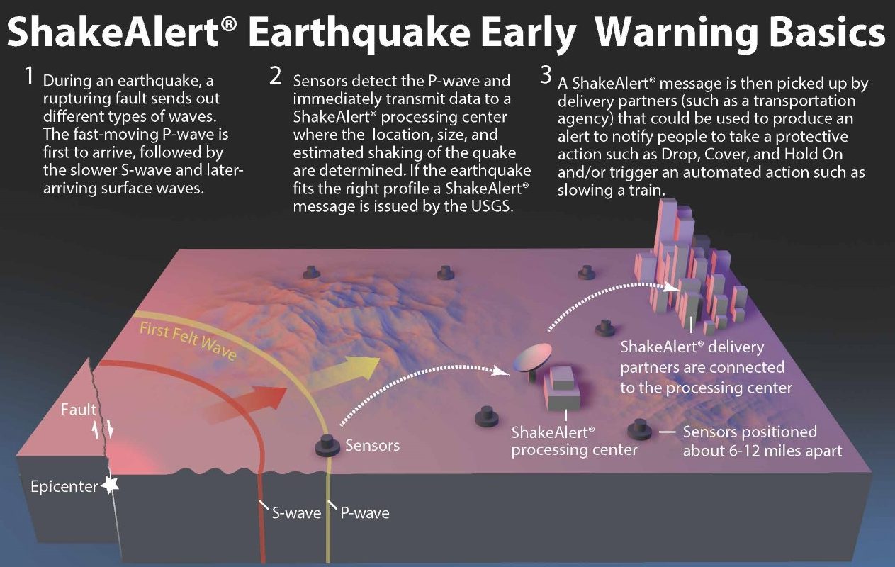
Multiple seismometers — scientific instruments that measure ground motion — detect a 7.0 magnitude earthquake in Washington, Oregon or California.
Seismic waves move fast, but seismometers move faster: The data zips from seismometer to processing center at the speed of light (670,616,629 mph), where algorithms calculate the area and intensity of shaking and sound an emergency warning to phones moments before shaking arrives: Drop. Cover. Hold on.
All of this takes about five seconds.
At most.
ShakeAlert’s Washington launch
Harold Tobin
Professor, Earth and Space Sciences
Tobin is the Director of the Pacific Northwest Seismic Network, the Washington State Seismologist, and was recently named the Paros Endowed Chair in Seismology and Geohazards.
On Tuesday, May 4, the ShakeAlert® Earthquake Early Warning system will publicly launch in Washington. The service will now be available throughout the entire West Coast via Wireless Emergency Alert (WEA) push messages delivered by the Federal Emergency Management Agency for earthquakes above a magnitude 5, and alerts for earthquakes greater than a magnitude 4.5 will be directly integrated into devices running on the Google/Android operating system.
“ShakeAlert adds early warning for earthquake preparedness,” says Harold Tobin, director of the Pacific Northwest Seismic Network (PNSN) and professor in UW’s Department of Earth and Space Sciences (ESS). “Using technology we have developed over a long time, we can now detect and rapidly calculate an earthquake’s location and magnitude, all in real-time. As soon as an earthquake starts and our sensors detect it, an algorithm that runs all the time on ShakeAlert computers calculates how far out the shaking is, and its potential significance.”
ShakeAlert was developed through a partnership and collaboration of the U.S. Geological Survey (USGS) and four universities: University of Washington, University of Oregon, University of California Berkley and California Institute of Technology to create a real time earthquake early warning system for the entire West Coast. The PNSN, based at UW, operates all seismometers from the California border all the way to the border with lower mainland British Columbia.
Earthquake 101
Read the UW News story about the launch of ShakeAlert
The earth’s crust is broken into thin, rigid tectonic plates. They move slowly over and around each other: This can lead to cracks, or faults. An earthquake can result from the sudden movement of the Earth’s crust at a fault line or plate boundary.
During an earthquake, a breaking fault sends out several types of waves. The first tremor, called a P-wave, spreads first to the seismic stations that measure it. But it’s generally not the most damaging wave. The next wave, called the S-wave, and the slower moving surface waves which follow cause the hazardous shaking.
Essentially, the Earth reacts the same way as a pond after a pebble is thrown into it; there’s an epicenter and then concentric circles of disturbance. Generally, the further away you are, the less you’ll notice the movement.
And the closer you are to the epicenter, the less reaction time you’ll have.
Time and place
The PNSN has about 385 seismic stations in the Pacific Northwest with 239 in Washington state — about 70 percent of their desired number. This number will continue to grow, says Tobin. Eventually, the entire West Coast system in service of ShakeAlert will have 1,675 seismometer stations. Right now, there’s around 1,300.
Although seismic stations are placed throughout the state, they’re concentrated in areas with a history of seismic activity, such as Puget Sound and the coast, and in areas where population is dense.
As it turns out, unfortunately people seem to prefer to live in the same locations as the major fault lines.”
– Harold Tobin
P-wave detection to message creation takes about 1-4 seconds, but if you’re near the epicenter you may get the message after shaking arrives. People 20-30 miles away may get a few more seconds. Further out, more time: Tobin estimates an earthquake with an offshore epicenter could give Seattleites 30 seconds or more to prepare.
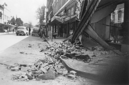
University of Washington Libraries, Special Collections, UW41088
On April 13, 1949, a 7.1 magnitude earthquake occurred in Western Washington, centered between Olympia and Tacoma. In Olympia, nearly all large buildings were damaged, water and gas mains were broken, and a large portion of a sandy spit jutting into Puget Sound disappeared. Credit: University of Washington Libraries, Special Collections, UW41088
Washingtonians can get ShakeAlerts delivered several ways. The first, the WEA, is a public safety system that allows people to receive geographically targeted texts on their cell phones, such as Amber Alerts for missing children or dangerous weather approaching. However, although WEA was designed to reach a large proportion of phones, it’s not designed to be extremely fast.
Building an alert into the DNA of your phone can speed things up, says Tobin. Google has added ShakeAlert into its Android phone operating system. He expects that in the near future, additional downloadable apps will be available for iPhone users.
Seconds count
Check to see if your phone is set up to receive wireless emergency alerts
Scientists detect earthquakes every day that no one ever feels. For a WEA message, an earthquake must reach a 5 magnitude to warrant a ShakeAlert; Android phones and cell apps may be as low as a 4.5 magnitude.
“If an earthquake will produce shaking virtually everyone feels in a given region, we’d like for them to have the alert, even if it’s not heavily damaging. It’s reassurance,” says Tobin. “We don’t want to bug people, but want to alert them if they’re likely to experience an earthquake.”
ShakeAlert is location-based; WEA systems broadcast to cell towers, and apps on your phone use location services to track where you are. It doesn’t matter where your phone is registered; if you’re on vacation in California but live in Washington, you’ll get alerts for California.
“The system doesn’t care if you just flew in from New York,” says Tobin.
Seis-ing it up
Paul Bodin
Research Professor, Earth and Space Sciences
Bodin is the Network Manager for the Pacific Northwest Seismic Network.
“The seismic network is a data telemetry network: It has an appliance to collect data at one end and a computer center at the other,” explains Paul Bodin, research professor at ESS and the network manager at PNSN.
When the ground begins shaking on a fault and waves radiate outward, the seismometer detects motion, converts it to an electrical signal and sends it to processing centers which interpret that data in about a third of a second, Bodin explains. Seismometers can be found just about anywhere, from urban buildings to remote mountaintops.
But not all stations are alike.
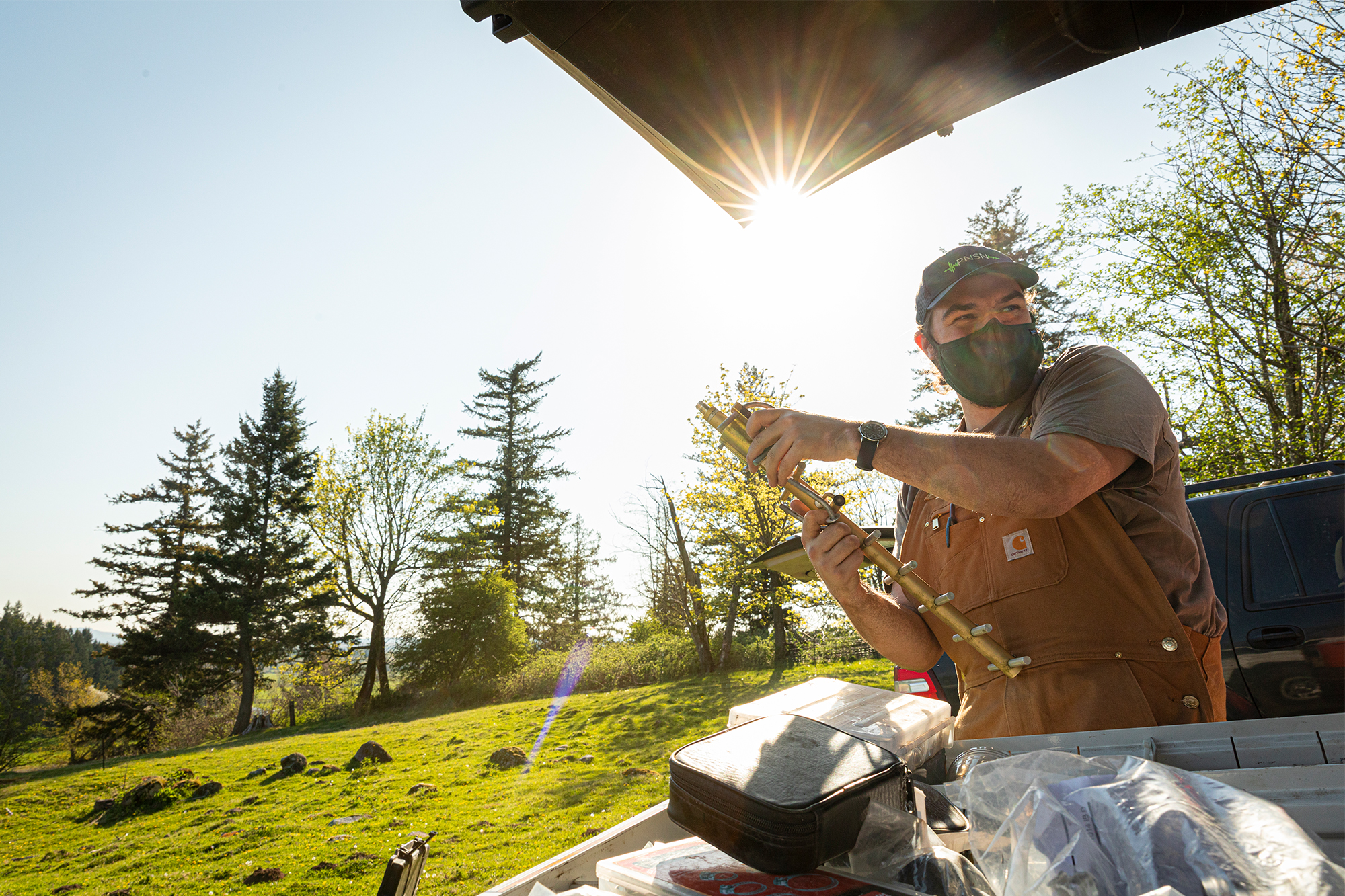
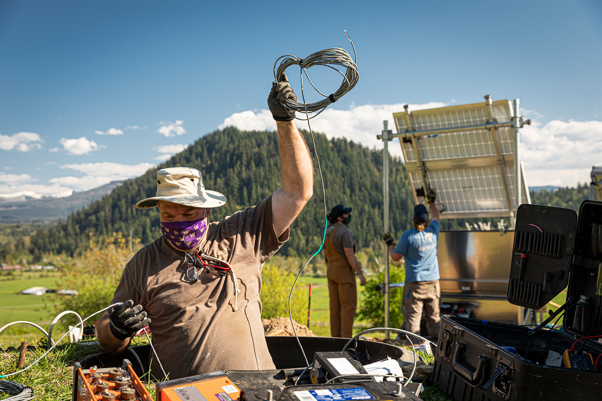
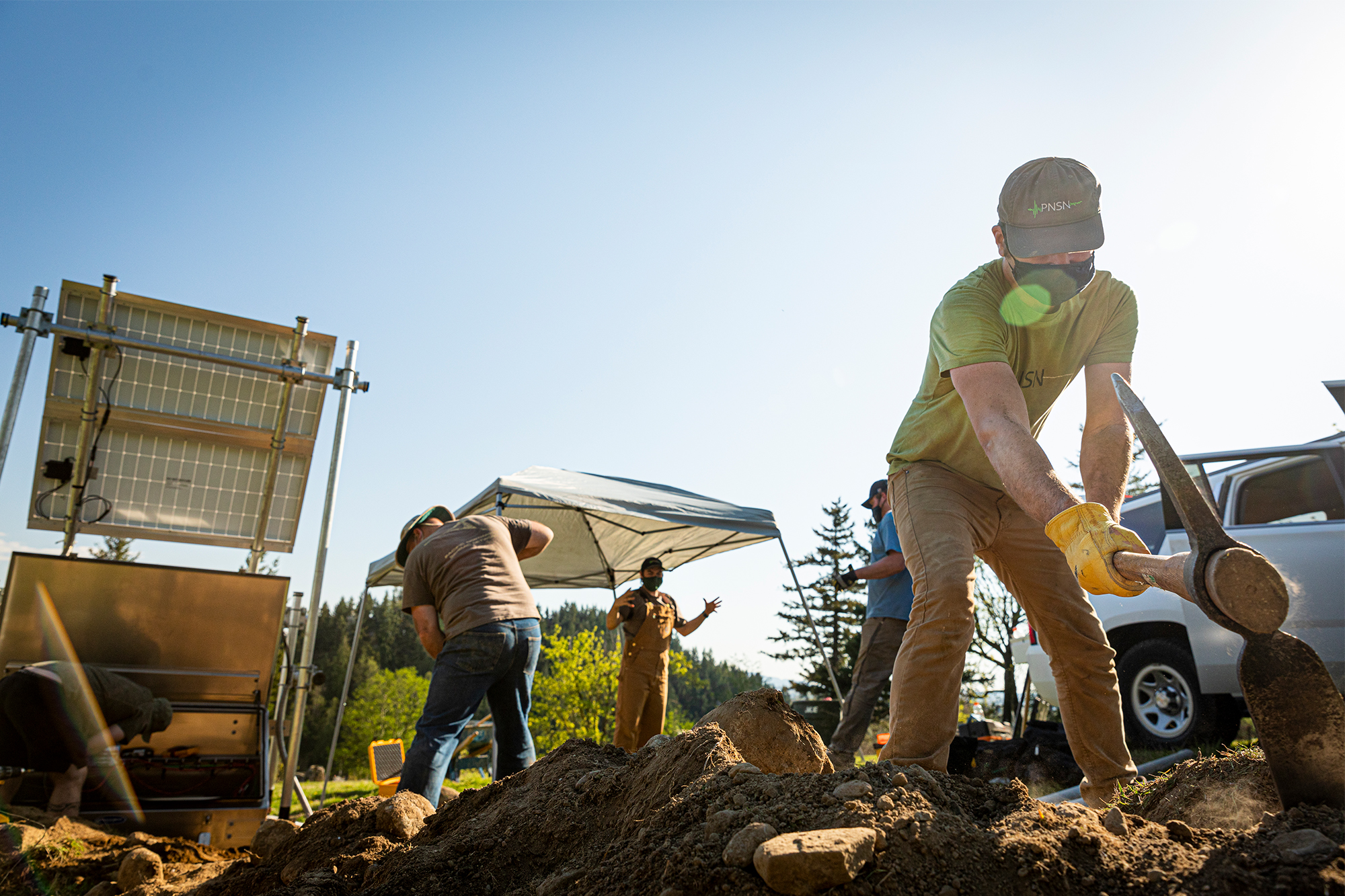
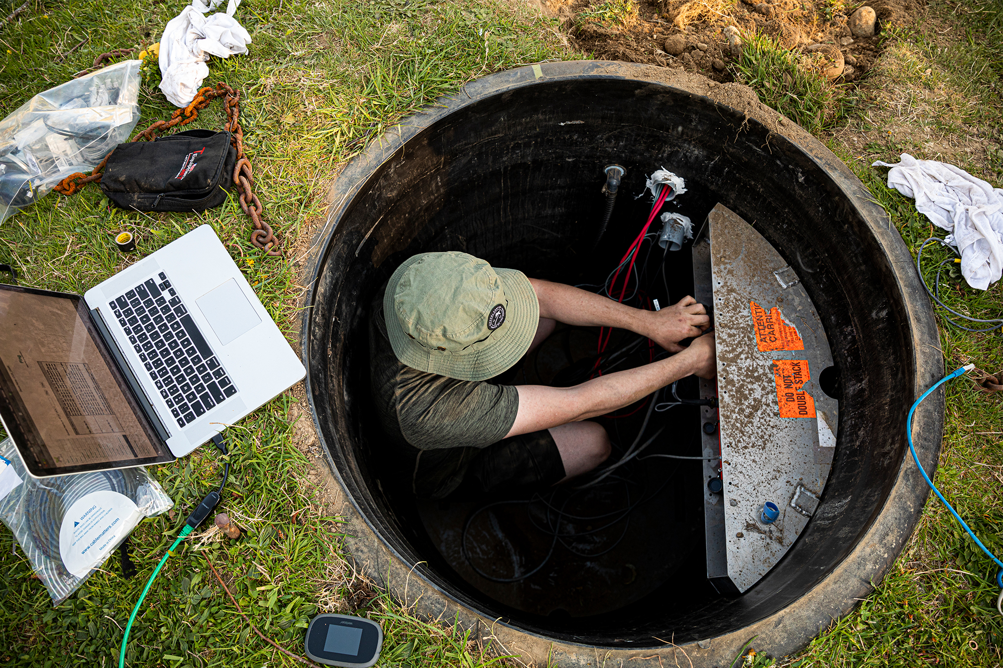
Rural seismometer sites have a solar panel and several backup batteries to power the seismometer’s communications equipment. They measure about 10 feet tall with a six-foot enclosure to protect the transmitters. The seismic sensor is buried about ten feet underground at one end of a 20-foot trench.
Gallery // A team from the UW-based Pacific Northwest Seismic Network installs a new solar panel array at a seismic monitoring site in Enumclaw, Washington in April 2021. The seismometer is one of hundreds that provide data for ShakeAlert.
Urban seismometers look different: They’re slightly bigger than a can of tuna and placed in 20-inch metal boxes, along with backup batteries and data recorders. You generally won’t find them inside high-rises; they need a view of the sky to relay GPS information and seismometers are sensitive to the motion of a big skyscraper.
Mouse Reusch, regional ShakeAlert coordinator at PNSN, says, “It’s hard to wrap your head around how sensitive some of these sensors are. They can sense motion thinner than one strand of hair. They can pick up a 5.5 earthquake on the other side of the planet.”
But it’s not as easy as staking out a shake-prone site and laying claim to it.
Generally, a seismometer needs to be located in a quiet area. Some examples of those areas are within national parks, pasture lands and managed forests. They can’t sit by a highway. And remote sites require solar access even in the dead of winter.
“We partner a lot with the Washington Department of National Resources, state parks and even private timber companies. They have been very kind,” says Reusch.
“Sometimes we have to put cattle-proof fencing around stations because cows use them to scratch their backs,” says Bodin. “It’s a constant fight with nature.”
Working together
As a major research university, UW sees a responsibility to help people in the state. One way is through working with state agencies to reduce harm from earthquakes throughout the region. As operator of the regional seismic network in the Pacific Northwest, UW works with many organizations to share knowledge and promote earthquake early warning throughout the West Coast as part of its ongoing public safety efforts.
This includes close collaboration with the USGS to ensure consistency and alignment with state agencies and partners, says Bob DeGroot, chair of the USGS ShakeAlert Joint Committee for Communication, Education and Outreach.
“Developing any new technology system is complicated. It’s been critical to get all three states to work together on a common goal, develop resources and ensure a consistent approach. We are working together to install seismometers, further refine algorithms and develop software that allows us to quickly identify and categorize earthquakes,” he says.
Help with systems
In addition to the public, there’s also another client for ShakeAlert: automated users. Instead of notifying people, you notify machines: ShakeAlert can turn data into a signal that can be read by machines, such as building control systems.
ShakeAlert can notify automated services in buildings or signal utility services. It can automatically open firehouse doors, so trucks aren’t trapped inside. It can shut off water valves to reservoirs to prevent contamination or issue a warning over an automated PA system to warn children at school.
Although ShakeAlert officially launches May 4, some organizations have been using it for years: RH2 Engineering in Bothell, Washington, has connected 13 different municipalities, water/wastewater districts and other utilities to receive ShakeAlerts since 2018.
Dan Ervin is executive vice president at Seattle-based engineering firm Varius; he’s worked closely on the development of ShakeAlert technology. Any business or utility operation can benefit from ShakeAlert, he explains.
“Pick any industry: It has an application for machine-to-machine connection. A hospital can use ShakeAlert to do things like shut off an MRI mid-procedure. You can alert airplanes not to land on a broken runway,” he says.
During an earthquake, water pipelines underground can separate. Pumps break. “A public water system could be out of service for 1-3 months. That’s a public health disaster,” Ervin says. “But with advance warning, utility companies can shut off valves to water control systems.”
Funding and future plans
The idea for ShakeAlert began with a gift in 2011 from the Gordon and Betty Moore Foundation to kick-start the development of an earthquake early warning system for the West Coast.
On the federal level, Congress has been supportive of the program, and funding has remained level or risen since the first request in 2014, says Bill Steele, director of communications at PNSN. The PNSN is sponsored in part by the USGS, the U.S. Department of Energy, and the states of Washington and Oregon, along with philanthropic funding.
Although it can be challenging to cobble together multiple large networks throughout the region, the team is proud of their work and its potential to serve the greater public good. Future plans include continuing to work on improving early warnings through evolving technologies and approaches.
“I like the idea that my job helps make the world a little better,” says Reusch. “We can’t control or predict earthquakes, but if this protects the water system, keeps people safe from falling things or lets someone grab their kids and hide under a sturdy table, that appeals to me.”
One tool of many
Although earthquakes can be scary and damaging, they are also infrequent. ShakeAlert is one of many things we can do to protect ourselves.
“Don’t run out of the front of the building if you get an alert. Drop, cover and hold on. If you’re in bed, protect your face and neck with a pillow,” Tobin says. “And as a society, we need to make our infrastructure more earthquake-safe all-around, like identifying dangerous structures or un-reinforced masonry and bridges.”
ShakeAlert is a useful service — but it’s not a panacea. It doesn’t take the place of planning. It’s simply one more tool to add to your earthquake preparedness toolbox.
“ShakeAlert isn’t going to filter your water for you, but studies have shown more than 50 percent of injuries in an earthquake are people falling or things falling on them. If we can help reduce that number, it can help us bounce back quicker from any earthquake or natural disaster,” adds Reusch.
Pacific Northwest Seismic Network
Learn more about the Pacific Northwest Seismic Network